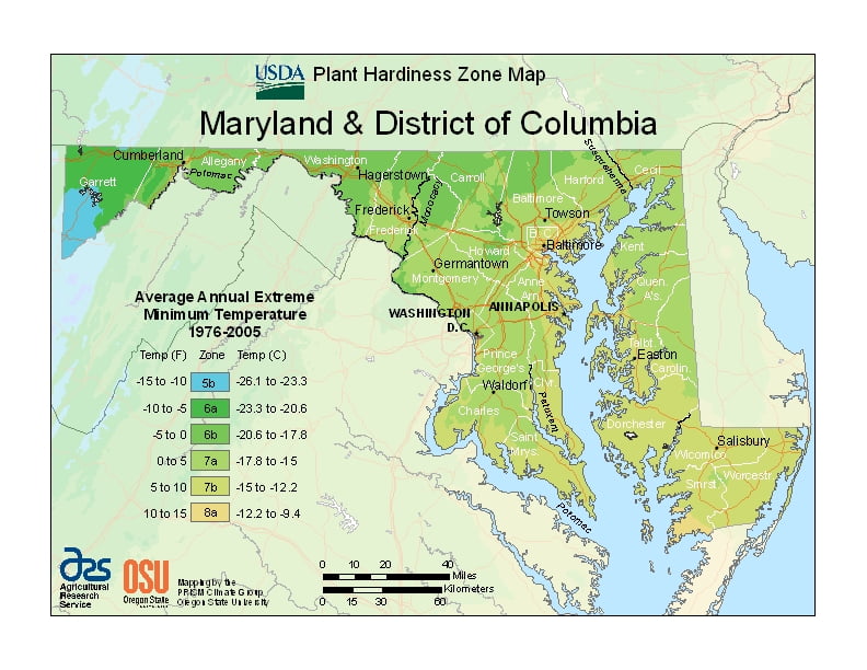
Maryland has a wide array of climates, due to local variances in elevation, proximity to water, ranging from USDA Plant Hardiness Zones 5b through 8a. Temperatures can vary per different areas of the state so get to know which zone your city is located in so that you can address and avoid potential issues before they become problematic.
The USDA zones map is a useful system for determining what plants will survive and grow in certain areas ofMaryland.
Understanding how these hardiness zones work means you can choose the right planting time, and optimize growing for your climate.
The eastern half of Maryland — which includes the cities of Ocean City, Salisbury, Annapolis, and the southern and eastern suburbs of Washington, D.C., and Baltimore — lies on the Atlantic Coastal Plain, with flat topography and sandy or muddy soil.
This region has a humid subtropical climate (Köppen Cfa), with hot, humid summers and a short, mild-to-cool winter.
The Piedmont region — which includes northern and western greater Baltimore, Westminster, Gaithersburg, Frederick, and Hagerstown — has average seasonal snowfall totals generally exceeding 20 inches (51 cm), and, as part of USDA Hardiness zones 7b and 7a.