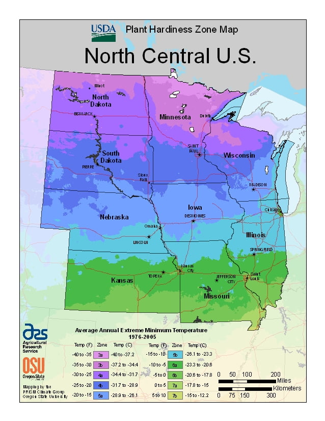
Gardening in the cooler region of North Central U.S., USDA Plant Hardiness Zones ranging from 3a through 7b. This region includes the 2nd coldest U.S. State of North Dakota, to a milder climate of the central Midwest State of Missouri.
The USDA zones map is a useful system for determining what plants will survive and grow in certain areas of North Central U.S.
Understanding how these hardiness zones work means you can choose the right planting time, and optimize growing for your climate.
States in USDA North Central U.S. Map
-

Illinois
Illinois has a climate that varies widely throughout the year. The USDA Plant Hardiness Zone classification ranges from 5a in Rockford, to 7a south of Mount Vernon city.
-

Iowa
Iowa has a humid continental climate throughout the state with extremes of both heat and cold. Snowfall is common, with Des Moines getting about 26 days of snowfall a year. The USDA Plant Hardiness Zone classification ranges from 4a in the north of the state, to 6a south of Ottumwa.
-

Kansas
Kansas’s climate can be characterized in terms of three types: it has humid continental, semi-arid steppe, and humid subtropical. The USDA Plant Hardiness Zone classification ranges from 5b in the north of the state, to 7a near Independence.
-

Minnesota
Minnesota experiences temperature extremes characteristic of its continental climate, with cold winters and hot summers. The USDA Plant Hardiness Zone classification ranges from 5b in the north of the state, to 5b near Fairmont.
-

Missouri
Missouri generally has a humid continental climate with cool, sometimes cold, winters and hot, humid, and wet summers. The USDA Plant Hardiness Zone classification ranges from 5b in the north of the state, to 7b near Poplar Bluff.
-

Nebraska
Nebraska has two major climatic zones. The eastern two-thirds of the state has a humid continental climate, although the southwest of this region may be classed as a humid subtropical climate. The USDA Plant Hardiness Zone classification ranges from 4a in the north west, to 5b in the south.
-
North Dakota
North Dakota has a continental climate with warm summers and cold winters. The USDA Plant Hardiness Zone classification ranges from 3a in the north, to 4b near Napoleon.
-

South Dakota
South Dakota has a continental climate with four distinct seasons, ranging from cold, dry winters to warm and semi-humid summers. The USDA Plant Hardiness Zone classification ranges from 3b in the north, to 5b near Pukwana.
-

Wisconsin
Wisconsin receives a large amount of regular snowfall averaging around 40 inches (100 cm) in the southern portions with up to 160 inches (410 cm) annually in the Lake Superior snowbelt each year. The USDA Plant Hardiness Zone classification ranges from 3b in the north, to 5b near Madison.


Zones in USDA North Central U.S. Map
 3a (-40 to -35 °F/-40 to -37.2 °C)
 3b (-35 to -30 °F/-37.2 to -34.4 °C)
 4a (-30 to -25 °F/-34.4 to -31.7 °C)
 4b (-25 to -20 °F/-31.7 to -28.9 °C)
 5a (-20 to -15 °F/-28.9 to -26.1 °C)
 5b (-15 to -10 °F/-26.1 to -23.3 °C)
 6a (-10 to -5 °F/-23.3 to -20.6 °C)
 6b (-5 to 0 °F/-20.6 to -17.8 °C)
 7a (0 to 5 °F/-17.8 to -15 °C)
 7b (5 to 10 °F/-15 to -12.2 °C)