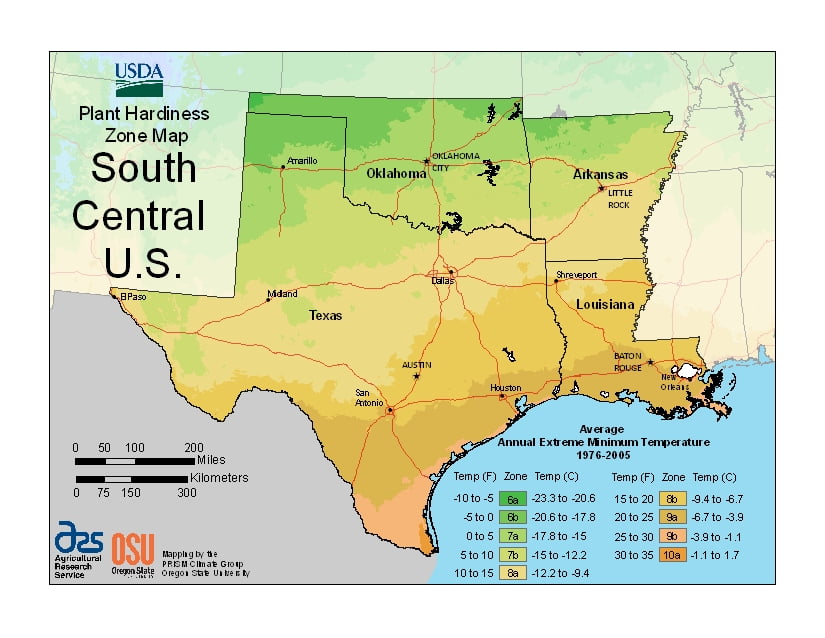
Gardening in the humid subtropical region of South Central U.S., USDA Plant Hardiness Zones ranging from 6a in the north of Oklahoma, through 10a in the coastal region of Texas.
The USDA zones map is a useful system for determining what plants will survive and grow in certain areas of South Central U.S.
Understanding how these hardiness zones work means you can choose the right planting time, and optimize growing for your climate.
States in USDA South Central U.S. Map
-

Arkansas
Arkansas generally has a humid subtropical climate. The USDA Plant Hardiness Zone classification ranges from 6b in Bentonville, to 8a around the city of Little Rock.
-

Louisiana
Louisiana has a humid subtropical climate, with long, hot, humid summers and short, mild winters. The USDA Plant Hardiness Zone classification ranges from 8a in Shreveport, to 9a around the city of New Orleans.
-

Oklahoma
Oklahoma is in a humid subtropical region with most of the state lies in an area known as Tornado Alley. The USDA Plant Hardiness Zone classification ranges from 6a in northwest counties, to 7a near Oklahoma City, with the high of 8a in the south east corner of the state.
-

Texas
The second-largest U.S. state of Texas is at an intersection of multiple climate zones gives the state highly variable weather. West Texas USDA Plant Hardiness Zone classification ranges from 6b to 9a while East Texas ranges from 7b to 10a.


Zones in USDA South Central U.S. Map
 6a (-10 to -5 °F/-23.3 to -20.6 °C)
 6b (-5 to 0 °F/-20.6 to -17.8 °C)
 7a (0 to 5 °F/-17.8 to -15 °C)
 7b (5 to 10 °F/-15 to -12.2 °C)
 8a (10 to 15 °F/-12.2 to -9.4 °C)
 8b (15 to 20 °F/-9.4 to -6.7 °C)
 9a (20 to 25 °F/-6.7 to -3.9 °C)
 9b (25 to 30 °F/-3.9 to -1.1 °C)
 10a (30 to 35 °F/-1.1 to 1.7 °C)