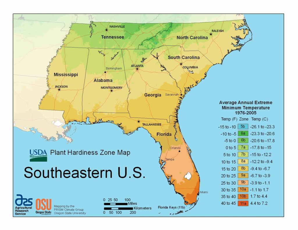
Gardening in the humid subtropical region of Southeastern U.S., USDA Plant Hardiness Zones ranging from 5b in Tennessee, through 11a in the coastal region of Florida.
The USDA zones map is a useful system for determining what plants will survive and grow in certain areas of Southeastern U.S.
Understanding how these hardiness zones work means you can choose the right planting time, and optimize growing for your climate.
States in USDA Southeastern U.S. Map
-

Alabama
The state is classified as humid subtropical with the average annual temperature of 64 °F (18 °C). The USDA Plant Hardiness Zone classification ranges from 7a near Huntsville City, to 9a near the coastal city of Mobile.
-

Florida
The climate of Florida is tempered somewhat by the fact that no part of the state is distant from the ocean. The USDA Plant Hardiness Zone classification ranges from 8a near Pensacola City, to 11a near the city of Miami.
-

Georgia
The majority of the State of Georgia is primarily a humid subtropical climate. The USDA Plant Hardiness Zone classification ranges from 6a north of Atlanta, to 9a near Savannah City.
-

Mississippi
Mississippi has a humid subtropical climate with long, hot and humid summers, and short, mild winters. The USDA Plant Hardiness Zone classification ranges from 7b near Tupelo, to 9a near Gulfport City.
-

North Carolina
North Carolina’s climate varies from the Atlantic coast in the east to the Appalachian Mountain range in the west. The USDA Plant Hardiness Zone classification ranges from 5b west of Asheville, to 9a near Charleston.
-

South Carolina
South Carolina has a humid subtropical climate, although high-elevation areas in the Upstate area have fewer subtropical characteristics. The USDA Plant Hardiness Zone classification ranges from 5b, to 8a near Charlotte.
-

Tennessee
Most of Tennessee has a humid subtropical climate, with the exception of some of the higher elevations in the Appalachians.. The USDA Plant Hardiness Zone classification ranges from 7a, to 8b near Bristol.


Zones in USDASoutheastern U.S. Map
 1a (-60 to -55 °F/-51.1 to -48.3 °C)
 1b (-55 to -50 °F/-48.3 to -45.6 °C)
 2a (-50 to -45 °F/-45.6 to -42.8 °C)
 2b (-45 to -40 °F/-42.8 to -40 °C)
 3a (-40 to -35 °F/-40 to -37.2 °C)
 3b (-35 to -30 °F/-37.2 to -34.4 °C)
 4a (-30 to -25 °F/-34.4 to -31.7 °C)
 4b (-25 to -20 °F/-31.7 to -28.9 °C)
 5a (-20 to -15 °F/-28.9 to -26.1 °C)
 5b (-15 to -10 °F/-26.1 to -23.3 °C)
 6a (-10 to -5 °F/-23.3 to -20.6 °C)
 6b (-5 to 0 °F/-20.6 to -17.8 °C)
 7a (0 to 5 °F/-17.8 to -15 °C)
 7b (5 to 10 °F/-15 to -12.2 °C)
 8a (10 to 15 °F/-12.2 to -9.4 °C)
 8b (15 to 20 °F/-9.4 to -6.7 °C)
 9a (20 to 25 °F/-6.7 to -3.9 °C)
 9b (25 to 30 °F/-3.9 to -1.1 °C)
 10a (30 to 35 °F/-1.1 to 1.7 °C)
 10b (35 to 40 °F/1.7 to 4.4 °C)
- 10b (35 to 40 °F/1.7 to 4.4 °C)
 11a (40 to 45 °F/4.4 to 7.2 °C)
 11b (45 to 50 °F/7.2 to 10 °C)
 12a (50 to 55 °F/10 to 12.8 °C)
 12b (55 to 60 °F/12.8 to 15.6 °C)
 13a (60 to 65 °F/15.6 to 18.3 °C)
 13b (65 to 70 °F/18.3 to 21.1 °C)